ArcGIS Enterprise 10.7 is available today!
The 10.7 release is packed full of new features and enhancements, from new options for your data, to new mapping styles, to brand new applications. 10.7 introduces both general features and enhancements as well as those focused on specific workflows such as imagery, workforce tracking, data science and more. Something for everyone!
We’ll cover a few highlights, but for a full list, visit the what’s new in the ArcGIS Enterprise portal and the what’s new in ArcGIS Server help topics.
Mapping and analysis
Introducing ArcGIS Notebook Server
ArcGIS Notebook Server brings a native Python notebook experience directly into your ArcGIS Enterprise portal to fuel data science workflows and to automate administrative tasks. When you install and configure ArcGIS Notebook Server with your deployment, users will be able to create, edit, and share Jupyter notebooks hosted in your portal. Each notebook author receives their own isolated workspace for advanced spatial analysis and data science modeling.
To learn about this capability, visit the Notebook Server announcement blog. You can also see it in action at this year’s DevSummit plenary!
Relationship style
A new smart mapping style for relationships lets you compare two numerical attributes on a map using color variation. For example, when analyzing a data set of commercial buildings, you might want to visualize both the occupancy rates and energy use and how these two attributes may be related (or not related!) Or, as seen below, you might want to map the paths of hurricanes to see both their relative speed and their relative pressure at once.
Head to the relationship style documentation topic for more details.

Generate Tesselations
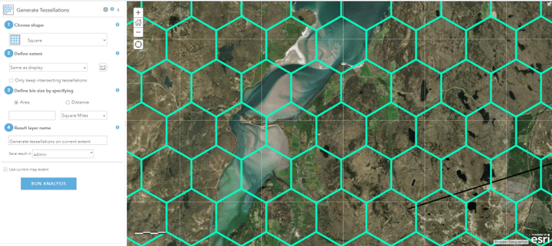
The new Generate Tesselations tool in the Map Viewer creates a layer of bins based on a specified shape and size. It divides up areas in your map that you could use, for example, as a study area. Check out the photo below of a tesselation created using hexagons – you can see how geography is divided up into these bins to help visually segment your data.
To learn more about how this tool works, visit the help topic Generate Tesselations.

New tools for GeoAnalytics Server
GeoAnalytics Server provides tools to help you process and analyze big data. At 10.7, GeoAnalytics Server brings in seven new tools, from being able to run a custom Python script against your GeoAnalytics server(s), to performing data management workflows, to regression and prediction analyses. As well, you can also take the results of your GeoAnalytics analysis and write them back to your own data stores, whether that is HDFS, cloud stores and more, keeping your data in one place if you desire.
For more information, visit the blog on GeoAnalytics Server at 10.7 (to be released soon!) and the what’s new help topic.
Data management
Offline map areas
You can now create offline map areas with a pre-determined extent. This makes it easier and faster to areas of your maps offline for use in workflows like field data collection. You can update offline areas on a regular schedule to reflect any changes in your web map.
Learn more about taking web maps offline.

Hosted feature layer views: define an area of interest
When specifying what defines a hosted feature layer view, you can use an area of interest as your definition. This can be a rectangle/square or a custom boundary. The hosted feature layer view will only provide access to the data within that area of interest for anyone with whom the view is shared. The other two view definition options – to define certain features or certain fields to display in the view – are still available for you to best define what data is shared in the view.
Here’s more on creating views.
New tile package file format
A new file format for tile packages is now available – the .tpkx. Now when you create a tile package in ArcGIS Pro, you can specify the output as either .tpk – the traditional format – or .tpkx, which uses an optimized storage structure. Developers will be pleased to know that Esri is making .tpkx an open specification. You can access it on GitHub to create your own custom solutions with tile package outputs.
Hosted feature layers: coded value domains
A new option for hosted feature layers allows you to set a prescribed list of values for fields in your data. This allows you to regulate the fields selected for data entry – erroneous inputs and misspellings are no longer a concern! With coded value domains, you can assign a pre-determined list or range of values that data editors will be able to choose from.
Here’s how to define attribute lists and ranges.

Publish to stand-alone servers from ArcGIS Pro
You can now publish map services and geoprocessing services from ArcGIS Pro to a stand-alone ArcGIS Server 10.7 site using ArcPy. Take a look at the ArcGIS Pro documentation to learn how it works.
OGC-compliant services from ArcGIS Pro
When publishing web maps and web layers from ArcGIS Pro to your ArcGIS Enterprise portal, you can now select OGC-compliant services, such as WMS and WFS, to be published as capabilities.
Administration
Introducing webhooks
Ever needed to know when an item was added to a group in your Enterprise portal, or when any users were deleted?
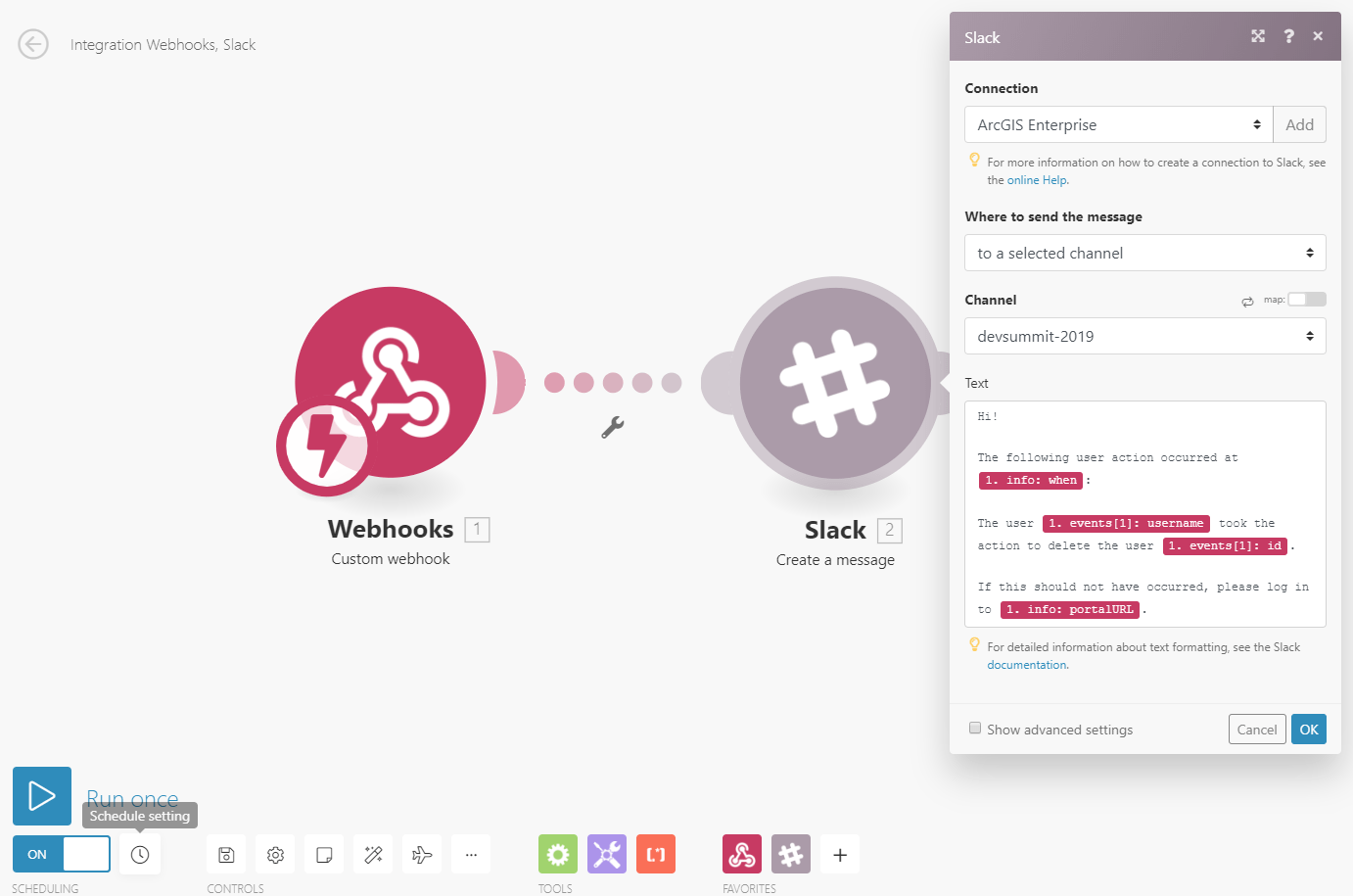
Webhooks serve a trigger-action function you can use to set up notification systems, automated quality assurance, and more. When a certain action occurs in the portal, a JSON message is posted to the webhook’s URL describing the action. You can set up a third-party service such as Microsoft Flow, Zapier, or IFTTT to “listen” to the webhook page and perform a response action or chain of actions.
This can be as simple as sending you an email notification, or as detailed as the metadata improvement bot David Vitale demonstrated in this month’s DevSummit plenary.

At 10.7, webhooks can be set up for three types of actions: users, groups, and items. For example, you might create one webhook to trigger each time a portal item is deleted, and another webhook for each time a user is created.
See the webhooks documentation for complete details.
Shared instances in ArcGIS Server
This is a game changer for GIS services. Traditionally, every service is powered by one or more dedicated service instances running on each machine in an ArcGIS Server site. Each active service instance takes up a certain amount of the machine’s RAM, even if it is not currently handling a service request. That means that when you have a number of services on your site that are running their own service instances but not receiving traffic, you’re expending machine resources that could be conserved.
Shared instances provide a solution. On ArcGIS Server machines starting at 10.7, you can choose to publish to a pool of shared instances. This pool can serve any number of services. For compatible map services published from ArcGIS Pro, you can configure them to use this shared pool, rather than their own dedicated instances. You can change the number of instances in this pool, and configure as many or as few services as you want to use the pool. For high-request services and/or services under service-level agreements, you may still choose to use dedicated instances.
If you have a lot of services running on your ArcGIS Server site, and many of those services receive infrequent traffic, configuring them to use shared instances reduces their resource usage, while maintaining optimal performance for all services.
More about shared instances in the 10.7 documentation topic Configure service instance settings.
New apps and products
ArcGIS Indoors
ArcGIS Indoors is a new product for indoor mapping, wayfinding, and location tracking. It uses indoor positioning system (IPS) technology to enable 3D mapping and navigation inside your building. Indoors is accessible through the ArcGIS Enterprise portal, and uses advanced technology for real-time streaming of building data.
Check out what ArcGIS Indoors can do for your organization.
Tracker for ArcGIS
At 10.7, you can now use the new application Tracker for ArcGIS to record where users are and where they have been. Tracker empowers location tracking through the Track Viewer web app and the Tracker for ArcGIS mobile app.
For more on Tracker for ArcGIS, check out Jeff’s announcement blog.
ArcGIS Excalibur
ArcGIS Excalibur, a new web app available in ArcGIS Enterprise with ArcGIS Image Server, modernizes and enhances the imagery analysis capabilities of your GIS. Excalibur provides a complete imagery workspace: search and discover image collections, perform advanced analysis and visualization, then create professional reports.
With ArcGIS Excalibur, you can work with imagery projects to organize all your resources and tools in a single location.
ArcGIS Companion
The ArcGIS Companion mobile app now supports ArcGIS Enterprise. Use the mobile app to log into your Enterprise portal, browse content, and manage users while on the go.
For more information on ArcGIS Companion, visit the Introducing ArcGIS Companion blog and the ArcGIS Companion GeoNet space.
In addition
But wait..there’s more!
User types
ArcGIS Enterprise 10.7 introduces a new licensing model for your users called user types. With user types, you can flexibly license users based on their workflows, whether they view content, edit it, collect field data, author and publish maps, and more. For more information on user types, reference the user types blog and the User types, roles and privileges documentation topic.
TLS and HTTPS
Two default security settings have been updated for ArcGIS Server and the ArcGIS Enterprise portal at 10.7. Now by default, only HTTPS communication is allowed, and only communication using TLS version 1.2 protocol is allowed.
Product lifecycle updates
With ArcGIS Enterprise 10.7, the product lifecycle has been updated. There is now the concept of long-term support releases (LTS) and short-term support releases (STS). Keep this in mind when choosing your upgrade schedule. For more information on the product lifecycle, please reference the Update to the ArcGIS Enterprise Product Lifecycle announcement.
Documentation updates
Last but not least, there is a new experience for ArcGIS Enterprise documentation. Last year, we introduced a redesigned documentation website; now at 10.7, a packaged version of this website, with all ArcGIS Enterprise 10.7 documentation in it, is made available in your installed deployment. That means that when you click “Help,” as from ArcGIS Server Manager or the ArcGIS Enterprise portal, you’ll be able to navigate from that component’s help to anywhere else in the ArcGIS Enterprise documentation, and can search across the entire platform to find what you need.
That wraps up some of the key enhancements at 10.7! The release video demos these – and others – to see the features in action:
When you are ready to get started with ArcGIS Enterprise 10.7, you can download your software and licenses through My Esri.
Enjoy 10.7!


Article Discussion: